WHAT WE KNOW
- The National Weather Service has issued a winter storm warning, which includes most of the Twin Cities
- A number of schools have already cancelled classes for Friday or plan to let out early
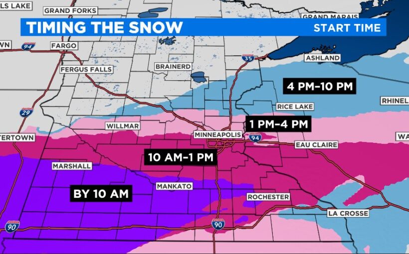
- Snowfall in the Twin Cities is expected by around noon and will impact the evening commute
- Heavy, wet snow will fall across southern Minnesota through the overnight hours
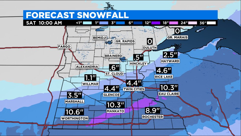
- Accumulations could be close to a foot in some areas
- Warmer temperatures and melting are in the forecast for next week
WHAT WE’RE TRACKING
- Where exactly the storm track (and heaviest snow bands) will fall
- Whether the Twin Cities will only see a couple inches of snow or in excess of 6 inches
WEATHER RESOURCES: School Closings | Radar | Weather App
MINNEAPOLIS (WCCO) — It could well be the first significant snow event of the season for the Twin Cities, but don’t expect it to assure a white Christmas. A winter storm is on track to give much of the southern part of the state at least a fresh coat of snow, but it might not linger.
The storm is expected to drop possibly as many as 4 to 8 inches of snow in the Twin Cities, and even more in parts to the south of the metro area.
WCCO’s Katie Steiner says that the snow is expected to arrive in Minneapolis-St. Paul around noon or a little thereafter.
“This is a system where once we see those first flakes start to fall, they won’t stop until Saturday morning,” she said.
Steiner said the models have been backing down on the snow totals in the metro area as the storm gets closer, but said it’s still possible we’ll see plenty to shovel.
The disagreement among models is due to the fact the heavy snow cut-off line looks to pass just north of the metro area. If that line shifts to the north or south, snow totals will be significantly affected.
In Southern Minnesota, we could see snowfall rates of 1 to 2 inches an hour in some spots where the heaviest band lines up. It’s possible more than a foot falls in the southern part of the state.
There's an unusually high amount of uncertainty on how far north the heaviest snow will fall. Despite our 4-8" (avg) snowfall forecast for the Twin Cities 30-45% chance that south metro will receive 12"+. It's all about where a 25-mi wide band of 1-2"/hr snow sets up this evening pic.twitter.com/CwlZDfOeY3
— Mike Augustyniak (@MikeAugustyniak) December 10, 2021
The heaviest snow bands look to fall along part of the Minnesota River Valley, extending just south of the Twin Cities. The snowfall will start with light snow before changing to wet, heavy flakes. The heavy snowfall is expected to continue into the overnight hours before the system pushes into Wisconsin early Saturday.
Most of the metro area and points south are under a winter storm warning, as issued by the National Weather Service.
Many Closings & Delays
Already a number of school districts have cancelled in-person classes.
The Rosemount-Apple Valley-Eagan School District said it’s cancelling classes due to the coming snow and a shortage of bus drivers.
Other south metro school districts, such as Bloomington Public Schools, Shakopee Public Schools, and Prior Lake/Savage Area Schools, say they’ll be dismissing students a few hours early, just as the heavy snow is expected to start falling.
Several other districts further south have canceled classes for the day. These include Northfield Public Schools, Mankato Area Public Schools, and Faribault Public Schools. A full list of school closings can be found here.
Parking & Plowing
If you park in the street, be ready for a possible snow emergency. Minneapolis could declare one as early as Friday, or possibly Saturday.
City officials in Minneapolis say that there’ll be around 50 plows out Friday clearing roads during the snowstorm.
And don’t forget to shovel sidewalks. Homeowners have 24 hours to clear a path in Minneapolis or face a possible ticket. All other properties like businesses and apartment complexes have to clear sidewalks within four hours of sunrise.
After The Storm, A Warm-Up
Saturday looks to be clear, with sunny skies and temperatures in the low 30s. This should help as crews work to clear the roads of snow and ice. Additionally, a warming trend will kick-off Sunday, when temperatures are expected to climb above freezing.
The warmer weather looks to extend through much of next week, peaking Wednesday when the mercury could reach the mid-40s in the Twin Cities. No matter how much snow Friday’s storm brings, much of it will melt in the following days, and whatever’s left could be washed away by a chance of mid-week rain.
For context, the average high temperature for mid-December in the Twin Cities is in the mid-20s. The average low is about 12 degrees.
More On WCCO.com:
- School Closings & Delays
- Minnesota Weather: Schools Cancelling Classes Ahead Of Winter Storm Warning
- Coronavirus In Minnesota: Second Student Dies Of School-Related Virus Infection This Year
- ‘I Personally Think He Shouldn’t Have Any Rental Properties’: Renter, Former Employee Speak Out Against Twin Cities Landlord
- 2 Teenagers Killed, 3 Injured In Crash Involving Stolen Vehicle, Police Say
Source: New feed


