

The sudden switch from scorching heat to soaking rain for much of eastern Australia in recent days has been underscored in a satellite image showing a rain band stretching across multiple states.
NSW and Victoria have multiple weather warnings in place for wind, rain, and floods, on the heels of destructive fires in both states.
Urgent flood warnings have been issued for eastern Victoria.
READ MORE: Three homes destroyed as NSW warned to prepare for 'horror' summer
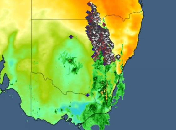

Weatherzone published an image yesterday afternoon showing the rainband extending from southern Queensland down through Victoria.
The plus signs indicate lightning strikes, mostly focused in NSW's north-east.
"Spring storms in sub-tropical regions tend to form at the confluence of warm and cool airmasses, and the background colours indicate the significant temperature differential between northeastern NSW and the rest of the state either side of the rainband," Weatherzone said.
Severe weather warnings are in place for both northern and southern NSW.
READ MORE: Children's hospital rape charge dropped for victim's mental health
The SES said damaging wind gusts of more than 90km/hr were expected in the central and southern ranges and coastal parts of the Illawarra and South Coast this morning.
As of 11pm overnight, winds of up to 126km/hr had been recorded at Thredbo, along with 102km/hr gusts at Murrurundi Gap and 98km/hr at Scone in the Hunter region.
NSW SES volunteers had received 250 calls for help in the 24 hours preceding 11pm, and a total of 421 since the beginning of this weather event.
Conditions are expected to ease by noon, but may persist longer in the state's south-east.
Sydney is forecast to hit a top of 23 degrees today, while Melbourne will reach 17 degrees.
