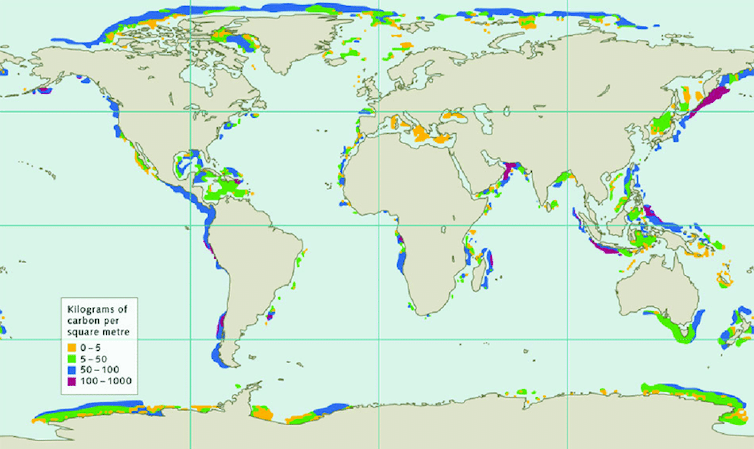
Buried beneath the oceans surrounding continents is a naturally occurring frozen form of methane and water. Sometimes dubbed “fire-ice” as you can literally set light to it, marine methane hydrate can melt as the climate warms, uncontrollably releasing methane – a potent greenhouse gas – into the ocean and possibly the atmosphere.
Colleagues and I have just published research showing more of this methane hydrate is vulnerable to warming than previously thought. This is a worry as that hydrate contains about as much carbon as all of the remaining oil and gas on Earth.
Releasing it from the seabed could cause the oceans to become more acidic and the climate to warm further. This is a dangerous set of circumstances.
The massive venting of methane from similar ancient marine hydrate reservoirs has been linked to some of the severest and most rapid climate changes in the Earth’s history. There is even evidence that the process has started again near the east coast of the US.
I have worked on hydrates for over a decade, mainly looking at the methane hydrate offshore of Mauritania, West Africa. Recently I have taken 3D seismic data intended to reveal oil and gas and repurposed it to map out the hydrates under the ocean floor. Ultimately, I wanted to work out if climate change is causing methane to bubble to the surface.
3D seismic is the geologist’s equivalent of the doctor’s CT scan. It can cover hundreds of square kilometres, and can reveal hydrates a few kilometres below the seabed. Hydrate is easily identified in these giant surveys because the sound waves created by a source of seismic energy towed by a ship reflect off the bottom of the hydrate layers.
Looking for methane using 3D seismic imagery
As I settled into a new way of life during the first COVID lockdown in early 2020, I reopened the much-studied dataset and started mapping again. I knew there were many examples of hydrate that had thawed as a result of warming since the last glacial period peaked some 20,000 years ago, and I knew we could detect this on the 3D datasets.
But what was the fate of the methane? Did it reach the oceans and atmosphere? Because if it did, this is a major clue that it could happen again.
Around continents, where the oceans are relatively shallow, hydrate is only just cold enough to remain frozen. So it is very vulnerable to any warming, and that is why these areas have been the focus of most scientific investigations.

The good news is that only 3.5% of the world’s hydrate resides in the vulnerable zone, in this precarious state. Most hydrate is instead deemed to be “safe”, buried hundreds of metres below the seabed in deeper waters tens of kilometres further from land.
But frozen methane in the deep ocean may vulnerable after all. In oceans and seas where the water is deeper than around 450 metres to 700 metres are layer upon layer of sediment that contains the hydrate. And some of it is deeply buried and warmed geothermally by the Earth so, despite being hundreds of metres below the seafloor, it is right at the point of instability.
Some layers of sediment are permeable and create a complex underground plumbing for the gas to move through if it’s liberated during climatic warming. Just like holding a football underwater methane gas wants to push upwards because of its buoyancy and burst through the 100s of metres of sediment layers.
Imposed upon this complex geology has been the seven glacials (or ice ages) and interglacials, which warmed and cooled the system repeatedly over the last million years.

Methane is migrating
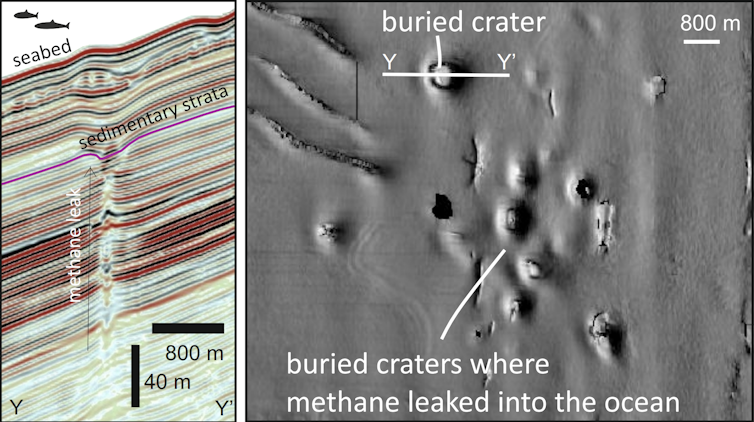
During this first lockdown of 2020 I found spectacular evidence that during warm periods during the last million or so years methane migrated laterally, upwards and landwards toward Africa and leaked in much shallower water. Beneath a layer of up to 80 metres of sediment are 23 giant craters on the ancient seabed, each one kilometre wide and up to 50 metres deep, big enough to be filled with multiple Wembley stadiums.
The seismic imaging provides the tell tale signs of methane immediately below the craters. And similar craters elsewhere form due to prolonged or explosive release of gas at the seabed.
These craters are not located in the vulnerable zone where all the attention has been – they are landward of it at about 330 metres water depth. With the discovery in hand, I gathered an international team of scientists (modellers, physicists, geoscientists) to work out what caused the formation of these remarkable things and when they formed. Our results are now published in Nature Geoscience.
We believe they formed as a result of repeated warming periods. These periods impacted hydrate in the deep ocean and the released methane migrated up to 40km towards the continent, to be vented beyond the shallowest hydrate deposits. So during a warming world the volume of hydrate that will be vulnerable to leaking methane is more significant than previously thought.
The positive outlook is that there are many natural barriers to this methane. But be warned, we expect that in some places on earth, as we warm the planet, methane from the deep will escape into our oceans.

Don’t have time to read about climate change as much as you’d like?
Get a weekly roundup in your inbox instead. Every Wednesday, The Conversation’s environment editor writes Imagine, a short email that goes a little deeper into just one climate issue. Join the 20,000+ readers who’ve subscribed so far.
![]()
Funding provided by NERC (NE/W00996X/1)


