
Tropical Cyclone Alfred is set to make landfall on Saturday morning, bringing damaging winds, heavy rain and floods to south-east Queensland and northern New South Wales.
The storm slowed on Wednesday and remained slow through Thursday, meaning the period of its crossing tomorrow may more extensive.
Bureau of Meteorology senior meteorologist Miriam Bradbury predicted today that the period of crossing onto land could take between six to nine hours.
LIVE UPDATES: Cyclone Alfred knocks out power to thousands

Here's a day-by-day breakdown of what to expect from Tropical Cyclone Alfred in the days ahead. Updated advice can be found on the Bureau of Meteorology website.
Friday
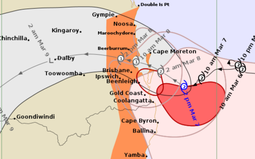
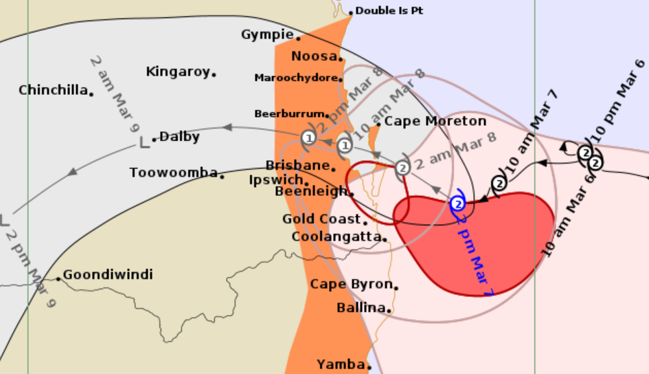
Tropical Cyclone Alfred is currently about 125km east/south-east of Brisbane and 90km east/north-east of the Gold Coast.
Sustained winds near the centre of the storm have been recorded at up to 100km/h and wind gusts have reached speeds of 140km/h.
While it isn't expected to make landfall until tomorrow morning, the effects are already being felt across parts of Queensland and NSW.
Heavy rainfall has been recorded across both states, as have abnormally high tides and damaging surf, which has already caused erosion at open beaches between Double Island Point and Grafton, and further south.
The Bureau of Meteorology has warned that dangerous flash-flooding is likely to develop from this afternoon.
READ MORE: X-ray shows diamond earrings worth $1.2k swallowed by theft suspect during arrest, police say
Damaging wind gusts overnight downed trees in some areas and gusts of up to 120km/h are currently lashing areas near the coast between Cape Moreton and Yamba.
Destructive gusts of up to 155km/h could hit the Moreton Bay Islands and exposed coastal locations on the northern Gold Coast from as early as this evening.
Alfred is still a category 2 storm and is expected to continue moving slowly towards the coast of southeast Queensland through the night.
Evacuation orders issued on Thursday have been extended across parts of Queensland and NSW, and people between Cape Moreton and Yamba, including the Moreton Bay Islands, have been advised to stay inside.
People between Yamba and Grafton in New South Wales, as well as Brisbane and Double Island Point in Queensland, have been warned to take precautions and await further advice.
Saturday
Cyclone Alfred is predicted to make landfall on Saturday morning, bringing with it wind gusts up to 155km/h in the early morning.
Its period of crossing is expected to last six to nine hours and storm may weaken as it crosses the coast into the mainland.
It may drop down to a category 1 storm as it continues its path inland, however heavy rainfall and damaging winds are expected to continue through Saturday.
Modelling suggests six-hour rainfall totals could exceed 200mm in parts of south-east Queensland and northern New South Wales, with some regions predicted to see 400mm in just 24 hours across Saturday.
Heavy rains are likely to exacerbate flood risks across low-lying regions.
Though it's expected to no longer be classified as a tropical cyclone by the end of Saturday, severe weather conditions may persist for days afterwards.
Sunday
By Sunday, Cyclone Alfred is expected to be declassified and tracking south across inland NSW but it could still bring heavy rain.
This will be especially concerning in already flood-prone areas.
Rain is also expected across regions further south, including Sydney and the Australian Capital Territory.
DOWNLOAD THE 9NEWS APP: Stay across all the latest in breaking news, sport, politics and the weather via our news app and get notifications sent straight to your smartphone. Available on the Apple App Store and Google Play.
