Heatwave conditions in Sydney and large parts of New South Wales are continuing for Australia Day today, but relief is in sight for millions of residents.
Several suburbs in the city are forecast to hit the 40 degrees mark, including Hornsby, Parramatta and Liverpool. Bondi in the eastern suburbs and the city centre aren't much cooler either, reaching 36 and 38 degrees respectively.
The scorching conditions forecast are coming after Sydney residents endured another muggy night, with temperatures of 25 degrees or more.
READ MORE: What the weather will be for every capital city on Australia Day 2024
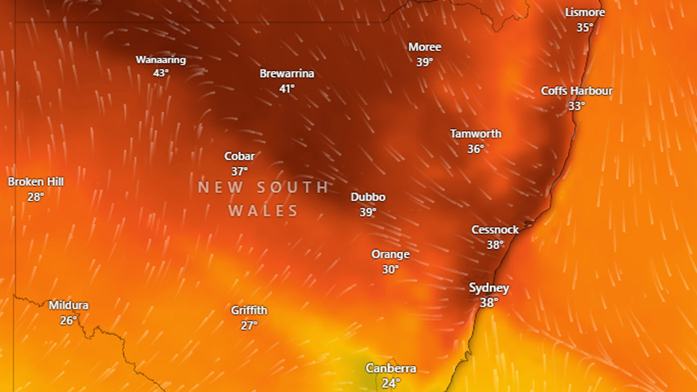
Regional NSW is also heading for another scorcher today. Many towns and regional cities can expect temperatures in the low to mid-40s.
There will also be north and north-westerly winds of up to 25km/h to 40km/h early today. Several areas are expected to experience high fire danger and there is a total fire ban in place for the state's Hunter region.
But relief from the extreme conditions is forecast by the late afternoon when cooler southwesterly winds sweep through. Temperatures are expected to drop by 10 to 15 degrees.
Tomorrow Sydney is forecast for a cloudy day with a top temperature of 27 degrees and the chance of showers.
https://twitter.com/NSWRFS/status/1750374504524652745?ref_src=twsrc%5Etfw
Meanwhile, Queensland yesterday recorded its second-hottest temperature on record.
The mercury reached 49.4 degrees at Birdsville, in the state's southwest, just after 2.30 pm.
That was just shy of the 49.5 degrees scorcher on Christmas Eve, 1972, which also occurred in Birdsville.
Meanwhile. Australia Day preparations and events have been cancelled in Adelaide after the South Australian city yesterday recorded its wettest January day in decades.
The relentless rain not seen since 1977 caused flooding and combined with plunging temperatures for an early taste of winter.